


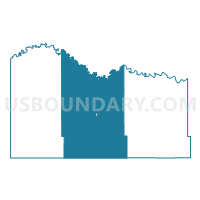
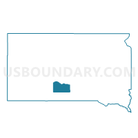
VTD-precinct 2, Mellette County, South Dakota
About
Outline

Summary
| Unique Area Identifier | 667569 |
| Name | VTD-precinct 2 |
| County | Mellette County |
| State | South Dakota |
| Area (square miles) | 446.16 |
| Land Area (square miles) | 445.24 |
| Water Area (square miles) | 0.92 |
| % of Land Area | 99.79 |
| % of Water Area | 0.21 |
| Latitude of the Internal Point | 43.57254170 |
| Longtitude of the Internal Point | -100.77719780 |
Maps

Graphs
Select a template below for downloading or customizing gragh for VTD-precinct 2, Mellette County, South Dakota


Neighbors
Neighoring Voting District (by Name) Neighboring Voting District on the Map
- VTD-precinct 1, Jones County, SD
- VTD-precinct 3, Mellette County, SD
- VTD-precinct 5 White River, Mellette County, SD
- VTD-precinct 6, Mellette County, SD
- VTD-precinct Mission City and N.Antelope, Todd County, SD
- VTD-precinct Parmelee, Todd County, SD
Top 10 Neighboring County Subdivision (by Population) Neighboring County Subdivision on the Map
- West Todd UT, Todd County, SD (4,863)
- East Todd UT, Todd County, SD (2,858)
- Central Mellette UT, Mellette County, SD (687)
- White River city, Mellette County, SD (581)
- Okaton township, Jones County, SD (46)
- Cody township, Mellette County, SD (33)
- Surprise Valley township, Mellette County, SD (25)
- Running Bird township, Mellette County, SD (23)
- Fairview township, Mellette County, SD (21)
- Red Fish township, Mellette County, SD (16)
Top 10 Neighboring Place (by Population) Neighboring Place on the Map
Top 10 Neighboring Unified School District (by Population) Neighboring Unified School District on the Map
- Todd County School District 66-1, SD (9,612)
- White River School District 47-1, SD (1,782)
- Colome Consolidated School District 59-3, SD (1,212)
- Jones County School District 37-3, SD (993)
Top 10 Neighboring State Legislative District Lower Chamber (by Population) Neighboring State Legislative District Lower Chamber on the Map
Top 10 Neighboring State Legislative District Upper Chamber (by Population) Neighboring State Legislative District Upper Chamber on the Map
Top 10 Neighboring 111th Congressional District (by Population) Neighboring 111th Congressional District on the Map
Top 10 Neighboring Census Tract (by Population) Neighboring Census Tract on the Map
- Census Tract 9402, Todd County, SD (5,161)
- Census Tract 9403, Mellette County, SD (2,048)
- Census Tract 916, Jones County, SD (1,006)